For those in the open data community, the recent release of Unique Street Reference Numbers (USRNs) and Unique Property Reference Numbers (UPRN) coordinates as open data has been welcome (and something that I’ve been lobbying for previously). However, the information released as open data is, to say the least, limited.
Essentially, the open data releases allow us to link UPRNs and USRNs to geographic coordinates. There are also some lookups supplied by Ornance Survey to allow UPRNs (properties) to be linked to the nearest USRNs (streets), as well as some other OS open data.
However, none of this contains any names or addreses. That’s not surprising, because OS makes a lot of money selling address data, and they don’t want to lose that revenue stream. However, it does mean that the open UPRN and USRN data isn’t as useful as it might be.
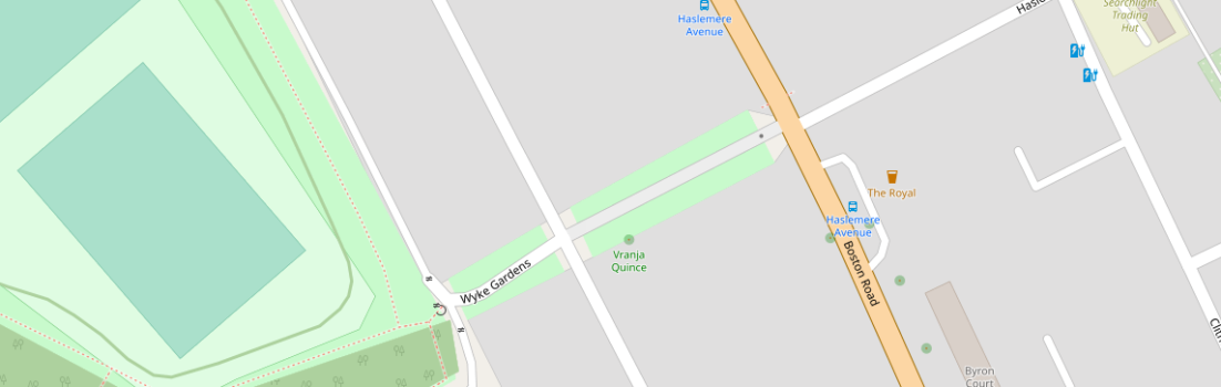
However, it is still valuable, and there have been discussions on the Open Streetmap mailing list about how best to use it in OSM. In particular, one contributor, Kai Poppe posed a question about an unnamed street in Ealing (the one in the middle of the map at the top of this page). In summary, the question was whether the open data might help us name that street.
I decided to look into it, since I’ve been experimenting with the open USRN and UPRN data as well, and linking names to numbers is one of the things I’ve been working on. My full reply to Kai is here, but this is an extract:
To find the USRN of the path, you need to use the lookup tables supplied by OS. Doing that, we find that the associated USRN is 20602512.
Now, there’s no open data source which will directly tell you the name of a USRN (at least, not until we start putting them into OSM). The long way of doing so is to find the matching LineString in OS OpenMap Local, and see what name it has there.
However, it can be done directly via a non-open source. If you go to https://www.findmystreet.co.uk/map and zoom in on the location, then click the street to bring up the USRN details, it will give the name (and also confirm that the USRN from the OS lookup table is correct). Or use the search box and search for USRN 20602512.
From an OSM point of view, that would normally be a dead end. Even if you can view the information on a non-open source, you can’t incorporate it into OSM. However, in this case, we already have an abbreviated name from an open source. So all we are learning from the closed source is the full text of the abbreviation. Whether that makes it acceptable to include the full name into OSM is a matter of debate. I’ll leave that decision up to others, but, for reference, the name of the street is Fairfield Road.
However, I’ve been doing a bit more research in this, as it piqued my interest. And the results are a little surprising.
For a start, USRN 20602512 doesn’t match Fairfield Road in OS LocalMap Open. In fact, there’s no Fairfield Road anywhere near there in OS LocalMap. Matching the coordinates indicates that, as far as OS is concerned, it’s a part of Southdown Avenue. That’s not particularly unusual, access roads off named streets often don’t have a name of their own, they’re either completely unnamed or share the name of their parent street.
However, I did wonder whether this might just be a limitation on OS Open Data, and whether OS MasterMap (the primary mapping product of OS) might actually include the name. That’s not reusable in OSM, or any other public website without paying a hefty licence fee, of course, but it might help point to an open source that does contain it.
But it seems that even MasterMap doesn’t have that name. You can check that by looking at Ealing’s online GIS website:
http://maps.ealing.gov.uk/Webreports/Planning/Planning.html
This is a planning application map, but it’s just a window into their GIS system and you can turn off the planning layers. Anyway, zoom all the way in to the street in question – I can’t give you a persistent link, but it’s just above the LA boundary in the bottom middle of the map – and… it still has no name. At the highest zoom level, this is MasterMap, and every named object has its name displayed. But there’s no name here.
Google, also, knows nothing of a Fairfield Road here. Using the Maps API to query the coordinates of USRN 20602512, we either get Southdown Avenue, again, or Boston Gardens, which is the postal address of buildings facing Boston Road. You can see that name on the road sign via Google Streetview:
https://goo.gl/maps/KGLbRC75mQw43PCV6
So, it seems that Fairfield Gardens isn’t known to either OS or Google. It is shown (in abbreviated form) on streetmap.co.uk, but at that zoom level, in London, that’s based on the Bartholomew A-Z maps rather than OS.
Given that, we can’t include the name “Fairfield Road” in OSM as it’s only available from non-open sources. But even those non-open sources don’t agree on the name. That seems to me to lead to two possibilities:
1. It doesn’t exist at all. It’s just a map trap designed to catch out unwary copyright infringers. That’s certainly a possibility, and A-Z maps are known to use those. But that doesn’t explain its presence in the USRN database.
2. The USRN name is wrong, but that error has propagated to the A-Z maps.
Personally, I think that the second option is the most likely. And, if so, it wouldn’t be the only error in USRN. One of the things I had to deal with a few years ago, in my capacity as a district councillor, was a country lane in my ward that had the wrong name assigned to it in USRN. After a bit of investigation, we concluded that it had simply been a transcription error back in the late 90s when the local gazetteer was first digitised, but it had gone unnoticed for a couple of decades simply because the wrong name never appeared anywhere in public until it eventually cropped up on a planning application. Getting the name corrected wasn’t an easy task, because of the length of time it had been wrongly recorded, but we did eventually manage to get it sorted out and the correct, historic name of the lane assigned to the USRN. Which is the name currently shown on Open Streetmap.
There are other issues with Ornance Survey’s linkage between UPRNs and USRNs. As far as I can tell, it seems to simply pick the USRN of the nearest public highway to the UPRN in question. In most cases, that works fine. Here, in Evesham,Worcestershire, for example, all of the properties associated with USRN 45405335 are actually on that street. But that’s not always the case. Here in Ely, Cambridgeshire, there are UPRNs assigned to USRN 12000472 that, in reality, are accessed from minor streets that are themselves accssed from USRN 12000472. And out here in the sticks in West Suffolk it’s even more extreme – there a properties assigned to USRN 14610160 that are not only nowhere near it, but are also not accessed via it at all.
This also illustrates another error in the USRN database. These rural roads in West Suffolk are listed as either “Poultry Road” or “Sedge Fen” in the USRN database. You can see that by looking at https://www.findmystreet.co.uk/map and searching for 14610160. But, in reality, the road name is “Sedgefen Road”, and this is correctly shown by MasterMap, Google and OS LocalMap Open. Open Streetmap renders it as “Sedge Fen Road”, which is how locals spell it (I know, that’s where I grew up), but it’s not the OS spelling.
This is, of course, one of the problems with proprietary data. It can be difficult to spot errors, because the people who are most likely to spot errors – members of the general public with local knowledge – tend not to have easy access to the data. Opening up the coordinates of USRNs doesn’t really help that. What we also need are the names. Because the more widely the data is redistributed and published, the more likely it is that people will spot the errors.
And we know there are errors. The non-existant “Brewers Hill Lane” (now correctly named Pear Tree Lane) was incorrectly applied to USRN 45405966 for nearly two decades. Sedgefen Road is still wrongly named on the USRN. And, I suspect, “Fairfield Road” in Ealing is yet another error.
So, we’re part of the way there with open data. But we still need the full National Street Gazetteer (NSG), complete with names and, crucially, the previous edit history, to be made open.
This doesn’t just matter to mapping geeks or open data geeks. The government wants UPRNs and USRNs to be much more widely used, in order to halp ensure that different references to the same property and the same street in different databases (eg, planning, council tax, land registry, telecomunications, roadworks, TROs, etc) all use a consistent ID. That’s an incredibly helpful principle, and, if properly implemented, should make a lot of online life simpler and easier. But it will only work if the data is reliable. And the best way to make sure it is reliable is to make it easy to spot, and correct, errors.
So, I’ll carry on campaigning for the full NSG to be open data, not just an extract from it. And, in the meantime, I’d suggest that everyone looks up their street at https://www.findmystreet.co.uk/map and check that it has the correct name. And, if it doesn’t – mercilessly pester your district and parish councillors until they finally manage to do what I did with Pear Tree Lane and get the name corrected!